Planning

Birmingham Development Plan 2031 (adopted January 2017)


Langley was allocated for housing in the Birmingham Development Plan in January 2017.
The Birmingham Development Plan Policy GA5 states:

“The Langley Sustainable Urban Extension will be an exemplar of sustainable development and a destination of choice for families wishing to live in Birmingham. The development will achieve the highest standards of sustainability and design and provide a range of supporting facilities to help foster a strong sense of community.”

“The new neighbourhood will provide for a mix of housing sizes, types and tenures, including affordable housing in line with the requirements in Policy TP31 (35%). There will, however, be a primary focus on the provision of family housing.”

“A range of supporting facilities will be included as part of the development including early years provision, new primary schools, a new secondary school, health care facilities and local shops and services.”

“The development will benefit from a new junction with the A38 and new connections into the built-up area.”
Langley Supplementary Planning Document (April 2019)


The Langley Supplementary Planning Document (SPD) provides the design framework for how Langley could be developed and was adopted as a Birmingham City Council guidance in April 2019.

The SPD allows the Langley Sutton Coldfield Consortium, who will be responsible for delivering Langley, to develop proposals that will form the basis of the site-wide Outline Planning Application.

The Langley SPD can be viewed here: https://www.birmingham.gov.uk/langleypeddimorespd

Outline Planning Application Submission (December 2021)


The Outline Planning Application was submitted to Birmingham City Council in December 2021. The application is for up to 5,500 dwellings and will include: affordable housing; a mixed-use district centre; two local community hubs; education provision (early years, up to three primary schools, one secondary school and sixth form); community facilities (including health facilities, extensive public open space, sports and play facilities); two new access points to the A38; new and amended principal access junctions along the western boundary of the site; highways improvement and mitigation; public transport provision; and a network of walking and cycling routes. The application number is 2021/10567/PA.

Summary information sheets, including answers to Frequently Asked Questions, are available to download from the resources tab.

Birmingham City Council Planning Committee resolved to grant permission for the Outline Planning Application on 22nd December 2022 subject to the signing of a S106 Agreement.

Strategic Infrastructure Planning Application (June 2023)


A Strategic Infrastructure Planning Application was submitted to Birmingham City Council in July 2023 (ref: 2023/04517/PA). This followed community and stakeholder engagement on the strategic infrastructure plans in 2022, which involved consultation with local residents and ongoing liaison with local stakeholders. Details of the public engagement event held in November 2022 are available here.

This application includes details of the proposed on-site strategic road, strategic open space and strategic drainage networks which will service, and provide the framework, for the areas of residential, education and mixed use built development. These areas include:

  • Three new community parks in the north, centre and south of the site;
  • Informal playing pitches, equipped play areas and recreational routes for walking, cycling and running with c.30% of the overall site ultimately provided as green infrastructure;
  • A network of new and existing roads, with walking and cycling routes separated from traffic along most primary and secondary streets to encourage active travel;
  • Roads designed to enable bus routes within the site and facilitate Bus Rapid Transit through the site;
  • The opening up of the Langley Brook Corridor to create a new linear park, providing a key north-south green link; and
  • Sustainable urban drainage systems (SUDS) with opportunities for habitat creation and wider amenity.

Following receipt of comments from local and statutory consultees, revised plans are being submitted to Birmingham City Council. The amendments include:

  • Details for formal sports pitch provision in a Community Sports Hub;
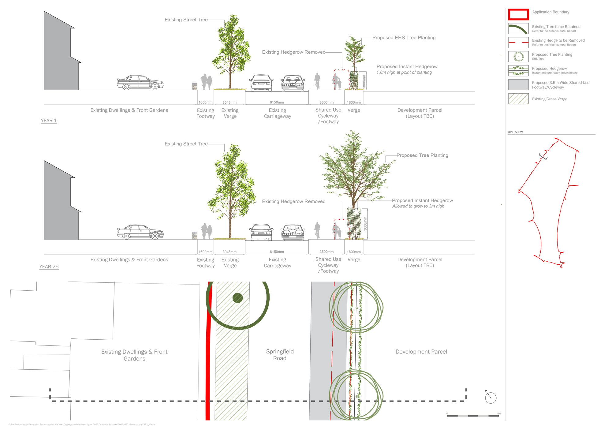
  • Retention of 330 & 332 Springfield Road in an enhanced landscaping context;
  • Amended orientation and landscaping for the primary substation;
  • Amended and additional surface water drainage attenuation features;
  • Submission of strategic infrastructure Design Coding;
  • Walking and cycling link along the western boundary of the site;
  • Amended widths and design for some of the primary and secondary streets;
  • Identification of proposed bus stop and street lighting locations; and
  • Submission of a comprehensive active travel plan.

For further information, please click the link below to view the key changes document:

Reserved Matters Applications (2025 Onwards)


It is the intention for reserved matters applications for the areas of built development to be submitted pursuant to the outline planning permission from the start of 2025 onwards.

  • Each House Builder undertakes public engagement on its plans.
  • House Builders submit Reserved Matters Application(s) following feedback from Birmingham City Council, the public and other stakeholders;
  • Birmingham City Council formally consults on application(s);
  • Birmingham City Council approve applications;
  • House builder constructs housing and parcel level infrastructure as required by the approval.

This cycle is then repeated for the remainder of the site and for the schools and non residential development.

“We have worked closely with Birmingham City Council and stakeholders during the development of the plans and look forward to continued engagement with local stakeholders and residents as we progress the proposals.”